
Zoom out of Madrid on Google satellite view and red clusters begin to emerge. Between grey, gridded avenues and barren parks, see clusters of winding narrow streets with red roof tiles and tiny plazas, which were once independent towns with their own culture, economy and architecture. Today, even though they lie well within the city limits of Madrid, they remain different.
VALLECAS
Before Madrid expanded, Vallecas was a shantytown on the outskirts of the capital. In the 1950s, it was like this…

Vallecas back then resembles the Cañada Real, a 16km-long shantytown curving around the outskirts Madrid. But in 1950, after residents successfully fought hard for paving slabs, sewage systems and running water, Vallecas ‘disappeared’, forfeiting its status as an independent town to make it an official part of the ever-expanding Madrid municipality.
Puente de Vallecas is a 30-minute walk from Atocha. You know you’ve arrived when you emerge from beneath a roaring eight-lane overpass to see an eclectic mix of housing. The same dusty streets that were established by Spanish migrants living in little white bungalows are now lined with blocks several storeys high.

But, apart from Vallecas’ original street layout, another ghost of this shantytown’s past lives on: poverty.
On this income map, we can see that Madrid’s ‘disappeared’ towns are still some of the poorest parts of Madrid. In the recent Spanish elections, a large number of their residents voted for parties offering radical change, which we can see in this map (look for the purple clusters, which represent Spain’s anti-austerity party, Podemos). Those splashes of purple concentrate in Lavapiés and Vallecas: two perfect examples of towns that remain culturally, economically and architecturally different from the city of Madrid.

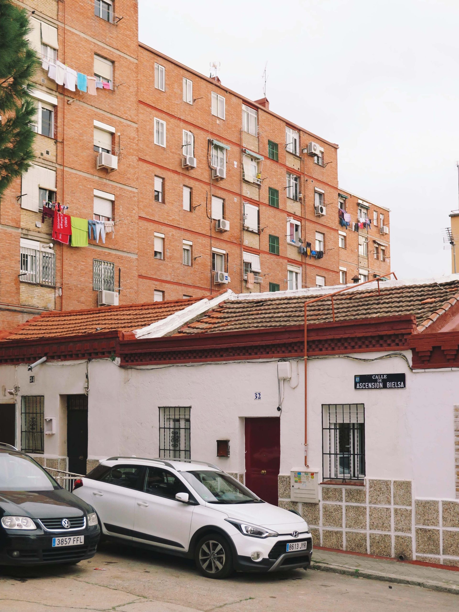
I took this photo (below) standing in Nueva Numancia, the northern part of Puente de Vallecas and one of the lowest earning neighbourhoods in Madrid, according to the income map. Its buildings are typically two to four storeys high and, looking at their doorbells, have between four and 10 flats in them – much fewer than in Madrid’s city centre.

Numancia’s streets are narrow and steep, tumbling into a view of Madrid City in the distance – the current invisible border is the roaring M30 motorway (cutting north-south through the middle of the photo below), which divides Vallecas and Pacifico.

The original invisible border of Puente de Vallecas, however, is actually an old stream called Arroyo Abroñigal that flows into the Manzanares. The barrio of Puente de Vallecas (Bridge of Vallecas) takes its name from the little wooden footbridge once suspended above the stream, which now runs underground, directly beneath the M30 motorway.
This underground stream is also where politics and wealth diverge. Crossing west above the stream and under the M30 motorway back towards Madrid, the vote shifts to the right and income doubles.


LAVAPIÉS
Just like Vallecas, the street layout of Lavapiés hasn’t changed since it was first laid. This old map below from 1658, half a century after Madrid became the capital of Spain, demonstrates just that, with Lavapiés’ ancient border very clearly defined by a sudden expanse of countryside.

That arid border is now a motorway known as Ronda de Atocha/Ronda de Toledo and quickly transitions from Madrid’s biggest cluster of leftist purple to blue, the right-wing PP.

The average income in these neighbourhoods is around just €11,000, yet they have some of the fastest growing property prices in the country, deepening Madrid’s inequality.

What is also very clear in the map above is that the average annual income rockets as you cross the motorway, just like in Vallecas. South of the motorway, incomes soar to an average of around €23,000. The differences in architecture across this road are also visible: the street layout becomes wider and more gridded, and the buildings are modern (about 100 years younger) and have underground carparks and swimming pools.

PUERTA DEL ÁNGEL
Meandering through Parque Madrid Río and crossing the Manzanares river by foot brings you close to nature. The migratory birds are singing from the blossoming trees and the carp are playing in the river’s current below – one of Madrid’s most profound invisible borders, geologically segregating Madrid’s richer and poorer.

The average annual income of residents of Barrio Puerta del Ángel is as low as €8,000, and their voting tendencies are no coincidence, as illustrated in the map below.

The architectural style of the sloping streets parallels that of Vallecas, but the opulent views rival those of almost any other part of Madrid (yes, that’s the Palace in the distance)…

Puerta del Ángel represents a greater percentage of Latin Americans than many other parts of Madrid, making the river an invisible border between nationalities too.
TETUÁN
Tetuán is where one of the richest parts of Spain borders one of the poorest.
The barrio of Tetuán was once an isolated village, having grown out of a military base established in 1860. A hundred years later, it ‘disappeared’, joining the conurbation of Madrid. Today, straddles an invisible border with Madrid’s financial district, Cuatro Torres.

Winding alleys end and wide avenues begin, where architecture, wealth and ethnicity change from one meter to the next – the invisible border being the Paseo de Castellana motorway.


MADRID IS A DIVIDED CITY
Tetuán, Vallecas, Lavapiés and Puerta del Ángel (and other neighbourhoods such as Carabanchel and San Isidro) have steeply sloping, winding streets. Interestingly, the topography of Madrid seems to be connected to its wealth.
Flat areas in the city are perfect for planned builds – larger housing projects with money behind them, and financial centres. Hilly areas, however, are developed more slowly depending on need. This is the more organic and traditional way for towns to form and is increasingly rare in this world, with the exception of shantytowns.
This style of urban planning, however, does not justify Madrid’s inequality. In a report by Philip Alston, the UN’s special rapporteur on extreme poverty and human rights, some harrowing home truths came to light.
Spain today needs to take a close look at itself in the mirror. What it will see is not what most Spaniards would wish for. The self-image of a close family-based society rooted in deeply shared values and social solidarity has been badly fractured by an economic crisis and the implementation of neoliberal policies. The local and familial safety nets that had been historically important continue to work for the well-off, but have been undermined for a large part of the population.
Prior to the crisis, Spain had been relatively immune to the rising inequality afflicting so many other countries, but since 2010, inequality has exploded. People face skyrocketing housing costs, privatization of apartment blocks, and aggressive evictions. Yet low cost social housing is almost nonexistent despite widespread agreement on its necessity. The system for providing social assistance is broken. It ought to play a significant role in reducing poverty, but is remarkably ineffective with wealthy families benefitting more from cash transfers than poor families.
I agree. But will Spain’s new government coalition take this on board? Here’s hoping.
For now, these sloping streets of eclectic homes and tightly-knit communities allow for stunning views of Madrid’s affluent areas within touching distance, but many can only look.


Leave a Comment