Enrique Bordes and Luis de Sobrón, creators of the map Madrid Bombardeado 1936-1939, are part of a growing movement to expose the lost stories of the Spanish Civil War. They’re tracking down our city’s hidden wounds and opening them back up in the hope that by redressing them properly, they can finally heal.
After spending two years digging through newspaper archives, collecting old photos and sifting through controversial historical accounts, the academic duo have assembled a detailed and accurate map of bombed Madrid. Each bomb impact is marked like a drop of blood, with some merging together to create larger stains.

Many details of what happened between 1936 and 1939 are still buried in library archives, kitchen drawers and at the depths of people’s memories. However challenging these clues are to find, they’re there for us to do so. The greatest challenge, though, is pulling the crumbling pieces of this puzzle together so that the full picture – one once lost in time and censorship – can finally be painted and seen for the very first time.
UNSILENCING THE PAST
After Franco’s death and a gruelling 36 years under his regime, those in power ordered shrapnel scars to be plastered over, records to be wiped, coordinates of mass graves to be deleted, and voices to be silenced. This collective amnesia is known as the “pact of silence”, and was believed by many at the time to be the only way in which Spain could move forward. It’s something Spain is still unravelling today, both physically and mentally.
Decades of pain was suppressed and, even now, we must tread sensitively while retracing our ancestors’ steps because there’s a danger that in revisiting one of the darkest eras in Spain’s history, we uncover not facts but rather interpretations of these facts. Newspaper clippings and personal accounts are inconsistent but photographs are much more reliable, and these are what Enrique and Luis are focusing their efforts on.
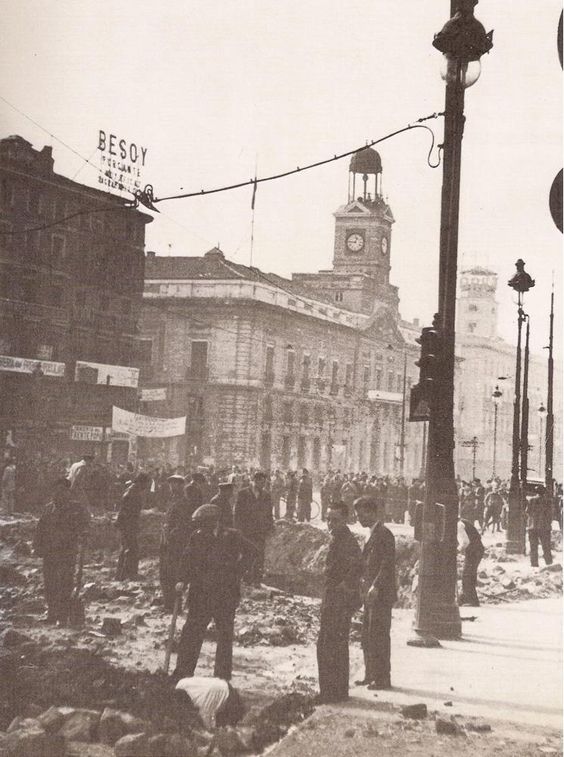
PINPOINTING THE BOMB BLASTS
Here are three photos of the bomb impacts on and around Puerta del Sol, one of which was so big that it blew right through to the metro tunnel beneath:


Below is the result of a night bomb on a residential building by metro Anton Martín:

On Cava San Miguel behind Plaza Mayor, a bomb blasted through two flats – one above the other:

The front of a building on Calle de los Estudios in La Latina was razed to the ground by a bomb blast:

This photo shows a bomb having just hit the Telefónica communications building – a major target during the siege:

The bomb blasts in all of the above photographs can be found on the map of Madrid Centro below, the heaviest of which was the Telefónica building on Gran Vía:

Here are two more photos: the university hospital left in ruins, and the impact of bombing on a building just off Calle Princesa, which was one of the main front lines during the Spanish Civil War:


These photographs are indicated on the map below, just by Moncloa and Princesa:

THE CRATER
A friend of mine had told me that there was a crater behind the university hospital, hidden deep inside a small, natural park. He pointed to the rough location of it on a map, and so off we went to investigate to see if it was still visible.
We went off-piste until there was an abrupt gap in the trees and the ground plunged. There it was: a huge crater caused by an underground explosion in a mine dug by Asturian miners to weaken Franco’s defences, who were positioned in the Hospital Clínico. There was no sign, no marker or plaque – just a fire pit in the middle, possibly used by those who live in the small slum just a dozen meters away.

I’ve marked where I believe it is on this map – the side-by-side impact circled in white:

80 YEARS ON
This map provides well-researched evidence that Madrid was pummelled by fighting during the Spanish Civil War, yet it took until almost 80 years later to be created, and it’s still not even complete.
For as long as bombings and bodies remain buried, the trauma of the Spanish Civil War will sit firmly on Spain’s shoulders and will continue to be passed down generation after generation. The country is clearly still processing its civil war and it’s projects such as this one, and this time-bending photography project, that are helping the entire nation deal with its uncomfortable past and, as quoted by the authors of the project,
To turn the page of the story, you must first write it.
INFO
- Follow Madrid Bombardeada on Twitter
- A limited number of maps can be picked up for free from a selection of municipal libraries.


Maps are a two-dimensional construct of the real world, a convenient way for us to plot and chart the space around us. This map is a bold and graphic account of the franquista assault on one of the world’s most cosmopolitan and beautiful capitals. I have read many first-hand accounts of the siege of Madrid from American journalists such as Hank Gorrell, Jay Allen, and (yes) Ernest Hemingway, who made it clear that the bombing raids on that city were nothing less than bestial. This map points out how cruel the attacks were: Infrastructure, hospitals, and communications were the targets for an adversary who intended to bring Madrid to its knees. I congratulate the researchers and hope they will continue to dig deeply into the past so they can unlock the realities of history. No doubt the process is painful, but the results are pure gold.
Congratulations on the article “Map of bombed Madrid”.
It is surprising to see how the scars of our Civil War are better understood outside of Spain
Nicely said, Paul! I couldn’t agree more.
Alternative perspectives sometimes help with understanding events so dark and complex, but I’m sure the war is best understood by the people who still carry it on their shoulders – many just don’t want to talk about it.
Congratulations for your article. A very interesting and, I think, correct reflexion about our still controversial past and the work we have carried out. And yes, the black point to the west of the Hospital Clínico is intended to be the graphic representation of the underground mine that burst and provoked the crater we can see nowadays. I thought nobody would realize that, but you did. That is gratifying for us. Not all the black points in the plan are so accurate, because it’s very difficult to know the exact place where the bombs fell, but the damaged buildings indicated in red color are all in documentary evidences.
Thank you for your interest in this research. You can visit the http://www.madridbombardeado.es website, where you can download an image of the plan, if you want. We’ve just made it public today.
Thank you Luís, and thank you so much too for your work – it’s a noble project and will help me explore the city in a new dimension! Thanks for the pdf, now I just need to get a hold of a paper map too 🙂